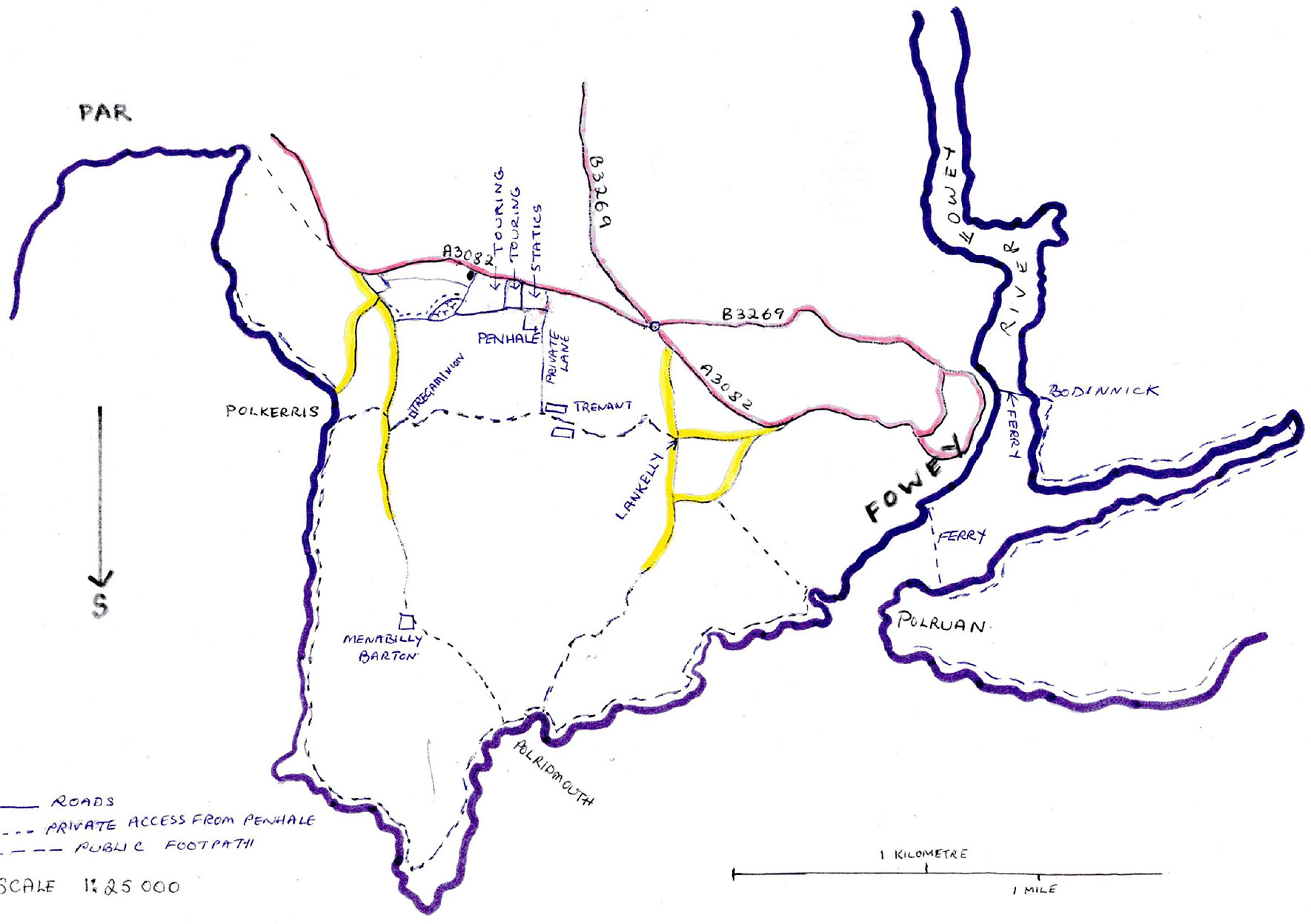
Walking Guide
To walk to Polkerris beach (1 mile):
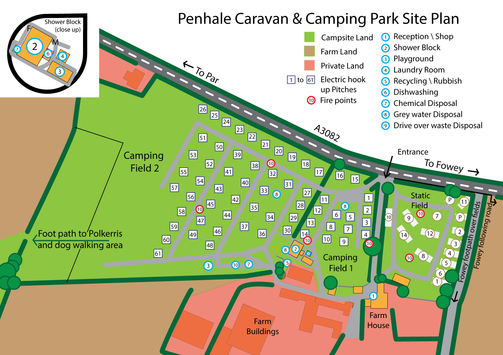
You will need sturdy shoes in wet weather as fields and footpaths can get muddy, and a torch at night. Go through the 1st camping field and to the far bottom left of the 2nd camping field and walk through the caravan storage area and the gap in the hedge, into the next field.
Walk up the path through the field, with the dog walking area to your left (the uncultivated area in the bottom left corner of the field), and the crops to your right, until you reach the left-hand hedge. With the hedge on your left, continue up the side of the field until you come to a gate leading on to the road above the beach.
Next, turn left and walk down the road for a short distance until you see the public footpath on the right, which takes you down to the beach. If you want to avoid the footpath, turn right when you reach the road and then first left down the road to Polkerris, but be careful of cars as the road is narrow and there is no pavement.
Sam’s on the Beach (restaurant) - Tel: 01726 812255 Web: www.samsfowey.co.uk
The Rashleigh Inn - Tel: 01726 813991 Web: www.therashleighinnpolkerris.co.uk
Polkerris Beach Company (water sports centre) - Tel: 01726 813306 Web: www.polkerrisbeach.com
To walk to Fowey (1.6 – 1.8 miles):
Go to the main entrance of Penhale, turn right and walk 20 yards until you reach a small lane on the right (see map). At this point either:
Go through the field gate at the top of the lane and walk along the top of the fields, with the hedge to your left and the sea to your right. This hedge runs parallel to the main road. When you reach the woods and can go no further along the fields, you will see another gate on the left which takes you back out onto the road (opposite the Texaco garage). Turning right here, it is only a short distance to the roundabout at the top of Fowey, where the pavement begins. You can now walk safely down into Fowey.
Alternatively - Walk down the small lane next to Penhale. At the bottom of the lane you will see a house on your left and below this a barn conversion. At this point the public footpath crosses east to west. Keeping between the house and the barn conversion, follow the footpath eastwards (left) and it will take you to Lankelly, at which point you are back on a road. At Lankelly either:
(i) Cross over to Lankelly Lane and walk to the end of the Lane. This now joins the main road leading into Fowey. Or –
(ii) Turn right at Lankelly Farmhouse and follow the road (signposted to Coombe).Turn first left, and then first right (Love Lane). This footpath then takes you down to St Catherine’s Castle and Readymoney Cove. Or –
(iii) Turn right at Lankelly Farmhouse and walk down the road until you reach the National Trust Car Park. Turn left (with the car park on your right) along a track and follow the path across fields looking out to sea on your right. Fowey is to your left and there are several paths leading down to Readymoney Cove which is at the bottom of Fowey.
Accessing the South West Coast Path:
You can access the Coast Path towards Par (west) by taking the path above the pub car park at Polkerris. To head in the other direction towards Polridmouth and Fowey (east), follow the instructions to Polkerris, but once on the road above Polkerris, instead of taking the first footpath on the right, down to the beach, walk a bit further down the road towards Menabilly and take the next footpath on the right (signposted), which takes you over a field and onto the Coast Path.